Quang Nam

16/12/2022 09:17 AM
Geography
Quang Nam is located in the middle of Central Vietnam and is surrounded by Thua Thien-Hue, Quang Ngai, and Kon Tum provinces. The Truong Son Mountains, Laos, and the East Sea also border the province.

Quang Nam has various of mountains and hills (covers 72% its surface) with many high mountains such as Lum Heo Mountain of 2, 045m, Tion Mountain of 2, 032m, Gole- Lang Mountain of 1, 855m... Main rivers run from Truong Son Range to East Sea as Vu Gia, Thu Bon, Tam Ky rivers.

Climate: Quang Nam's climate is influenced by monsoon. The annual average temperature is 250C. It is hot and dry from February to April and rainy from September to December. The average humidity is about 84%. The annual average rainfall is 2, 000mm. The average sunny hours: 1, 944 hours/years. 

Tourism
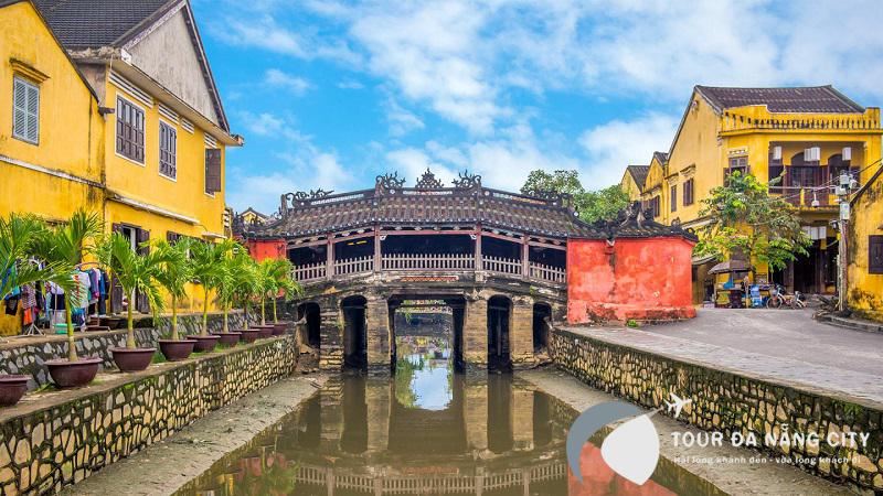
Experiencing the ups and downs over the years, Quang Nam still preserves the unique historical and cultural remains of the past along with rich human values. Some of the typical cultural sites include: Hoi An Ancient Town, My Son Holy Land, Tra Kieu Old Champa Capital, Cham Towers in Khuong My and Chien Dan, which record the remains of Sa Huynh, Champa and the Dai Viet civilization.
 

During many wars, Quang Nam was one of the cradles of the revolutionary movement. Bo Bo, Nui Chua, Vinh Trinh, Cho Duoc, Chu Lai and underground tunnels of Ky Anh, the Ho Chi Minh Trail have gone down in history as the destinations for tourist to stop and visit the former battle fields.

The province possesses 120km of coastline stretching form Dien Ngoc to Dung Quat with many beautiful, clean and deserted beaches. The beaches of Dien Duong, Cua Dai, Binh Minh, Tam Thanh, Ky Ha and Bai Rang together with the lake of Phu Ninh, the rivers of the Thu Bon and Truong Giang and the island of Cham are ideal tourist attractions.

Hoi An Ancient Town and My Son Cham Towers have been recognized as World Cultural Heritage since 12/1999.

Transportation
Quang Nam Province is located in the middle of Vietnam, 860km from Hanoi, 947km from Ho Chi Minh City, and 108km from Hue City. The province is on the National Highway 1A, the South- North railway and on the route of Danang?- Quang Nam- Kon Tum - Gia Lai - Dak Lak - Dak Nong - Binh Phuoc. Hoi An is 32km from Danang and can be reached by car, bus or minibus.
Other post

Sapa

Hang Located 38km from Lao Cai City, Sapa is a mountainous district of Lao Cai Province. Sapa District is very well-known with Sapa Townlet, a beautiful and romantic resort...

Quang Binh City

Located in North-Central Vietnam, Quang Binh Province is surrounded by Ha Tinh Province on the north, East Sea on the east, Laos on the west and Quang Tri Province on the south...

Nha Trang City

Considered Vietnam’s most famous seaside resort-town, Nha Trang attracts foreign tourists for not only its stunningly pristine beaches but also the urban atmosphere of a young tourist city...

Hue City

Hue city is one of places which have many cultural heritage. Up to now, there is no place like Hue remaining a lot of originally historical vestiges as in this ancient Capital City...

Ho Chi Minh City

In the core of the Mekong Delta, Ho Chi Minh City, formerly known as Saigon, is second the most important in Vietnam after Hanoi. It is not only a commercial center but also a scientific, technological, industrial and tourist center. The city is bathed by many rivers, arroyos and canals, the biggest river being the Saigon River...

Hanoi Capital

Hanoi is located in the Red River Delta, in the center of North Vietnam. It is encompassed by Thai Nguyen, Vinh Phuc provinces to the north, Hoa Binh and Ha Nam to the south, Bac Giang, Bac Ninh and Hung Yen provinces to the east, Hoa Binh and Phu Tho to the west...

Halong City

Halong City, formerly the Hon Gai Town, is the cultural, economic and political centre of Quang Ninh Province. It borders Cam Pha to the east, the Yen Hung District to the west, the Hoanh Bo District to the north and Halong Bay to the south with the coastline of 20km...

Hai Phong city

Hai Phong is a large city with an important seaport of Vietnam. Hai Phong is near Quang Ninh Province to the north, Hai Duong Province to the west, and Thai Binh Province to the south...

Dalat city

Dalat, capital of Lam Dong Province, is located approximately 308km northeast of Ho Chi Minh City. At an elevation of 1, 500m, Dalat bears the look of an Old French city. It was founded in 1897 when Doctor Alexandre Yersin recommended that the area be developed as a resort town...

Da Nang City

Danang City is located in middle of Central Vietnam, between Hanoi and Ho Chi Minh City, separated from Laos by the western Truong Son Mountains. It is surrounded by Thua Thien-Hue along the northern border and Quang Nam on the southern border. It is embraced by the East Sea with 150km of seacoast.

Can Tho city

Can Tho City is located in the center of the Mekong Delta. It is contiguous to 5 provinces: An Giang on the north, Dong Thap on the north-east, Hau Giang on the south, Kien Giang on the west, and Vinh Long on the east. Can Tho has a complex of rivers and canals such as Hau, and Can Tho rivers, Thot Not, O Mon canals. Among them, the Hau Riveris considered a benefactor of this region, since yearly floods deposit large quantities of alluvia to the rice fields. Thank to that Cantho becomes "the green lungs of the Mekong Delta".The climate is harmonized with few of storms. It is hot, humid all year. Rainy season lasts from May to November, and dry season lasts from December to April. The annual average temperature is 27oC.

Quick Question?

If you are interested in booking tours, cruises, services, other information with us, please enter your name, email and message.
Send

Tripavisor

FanPage

©2021 http://vietnamanztravel.vn/.